
We want to improve local travel routes.

We want to improve walking and cycling routes to give better access to jobs, shopping, schools and leisure areas.
We also want to see Norton Canes served by adequate bus services.
Bus Services
Up to £575,000 has been made available to Staffordshire County Council for bus service improvements via a planning obligation agreement in connection with the large housing development off Norton Hall Lane.
It is being used to connect the southern part of the village with the Kingswood Lakes employment and shopping area and Cannock Town centre.
An hourly daytime service running weekdays and Saturdays has commenced with this funding. It links Cannock with Brownhills via the Orbital Centre, Norton Green Lane, Walsall Road, Jerome Road and Brownhills Road.
The other existing bus service connecting Cannock, Norton Canes, Burntwood and Lichfield, runs at 30 minute intervals also on weekday and Saturday daytime.
Views Expressed by the Community [include link to consultations page]
At an earlier stage in the preparation of the plan, before the new service via Kingswood started, a survey of local people was carried out which obtained over 100 replies.
This showed that most bus users were over 65 and female; the majority of trips were to Cannock, Lichfield and Walsall; most trips were for shopping and or health appointments; most users had bus passes; and few people used buses for journeys to work.
The main comments were:
- Services are too infrequent. Should be every 30 minutes, should be extended to operate in the evenings until 11pm and have some service on Sundays.
- Services are not reliable enough, often failing to turn up.
- Those without bus passes considered fares to be too expensive.
- A decent bus service is essential for the elderly and young people/students who can’t afford a car.
- More housing and less public transport make the village more isolated.
- Better bus shelters
Walking and Cycling
As well as improving public transport, we want to make sure people can get to important destinations easily on foot or on bike.
There are six key walking/cycling routes to and from the village which have specific functions, which we think should be improved:
- 1 – FIVE WAYS/NORTON CANES HIGH SCHOOL
For students at Norton Canes High School who live at the northern end of the catchment area in Heath Hayes, there is an existing footpath/cycle route from near Five Ways Island along the line of a former colliery railway to the junction of Burntwood Road and Brownhills Road with a separate more informal link across the rear of the school to Burntwood Road. - 2 – CANNOCK EXTENSION CANAL
For workers at Watling Street and Lime Lane business parks, users of the retail/food and drink facilities on the A5 and the proposed extension to Watling Street business park, and for leisure users accessing the canal towpath of the Cannock Extension Canal south of the A5. There is a potential route along the line of the filled former canal which is partially blocked south of the M6 Toll. There is also no safe crossing of the A5 where the canal towpath reaches the road. - 3 & 4– BROWNHILLS ROAD and NORTON EAST ROAD to CHASEWATER For leisure users accessing Chasewater Country Park the footpath link opposite Red Lion Lane currently gets badly waterlogged and needs improvements. The other two links to Chasewater from Norton East Road are also in need of improvement with the southernmost of these being unsuitable for people with mobility problems because of levels issues.
- 5 – NORTON HALL LANE/KINGSWOOD
For workers and leisure users accessing the employment, shopping and open spaces of Kingswood and the Orbital centre, there is no safe access from the south-west of the village. The public footpath from the rear of St. James’s Church should be realigned to join the network of paths at Kingswood without users having to use part of Washbrook Lane which has no separate footway and is unsafe. - 6 – NEW FACILITIES SOUTH OF CANNOCK ROAD [link to be added to map] For residents accessing the new country park and primary school as part of the proposed major new housing development south of Cannock Road, improvements are required to Stokes Lane and Long Lane, which are exiting public bridleways, to link the new infrastructure to the village at Chapel Street.
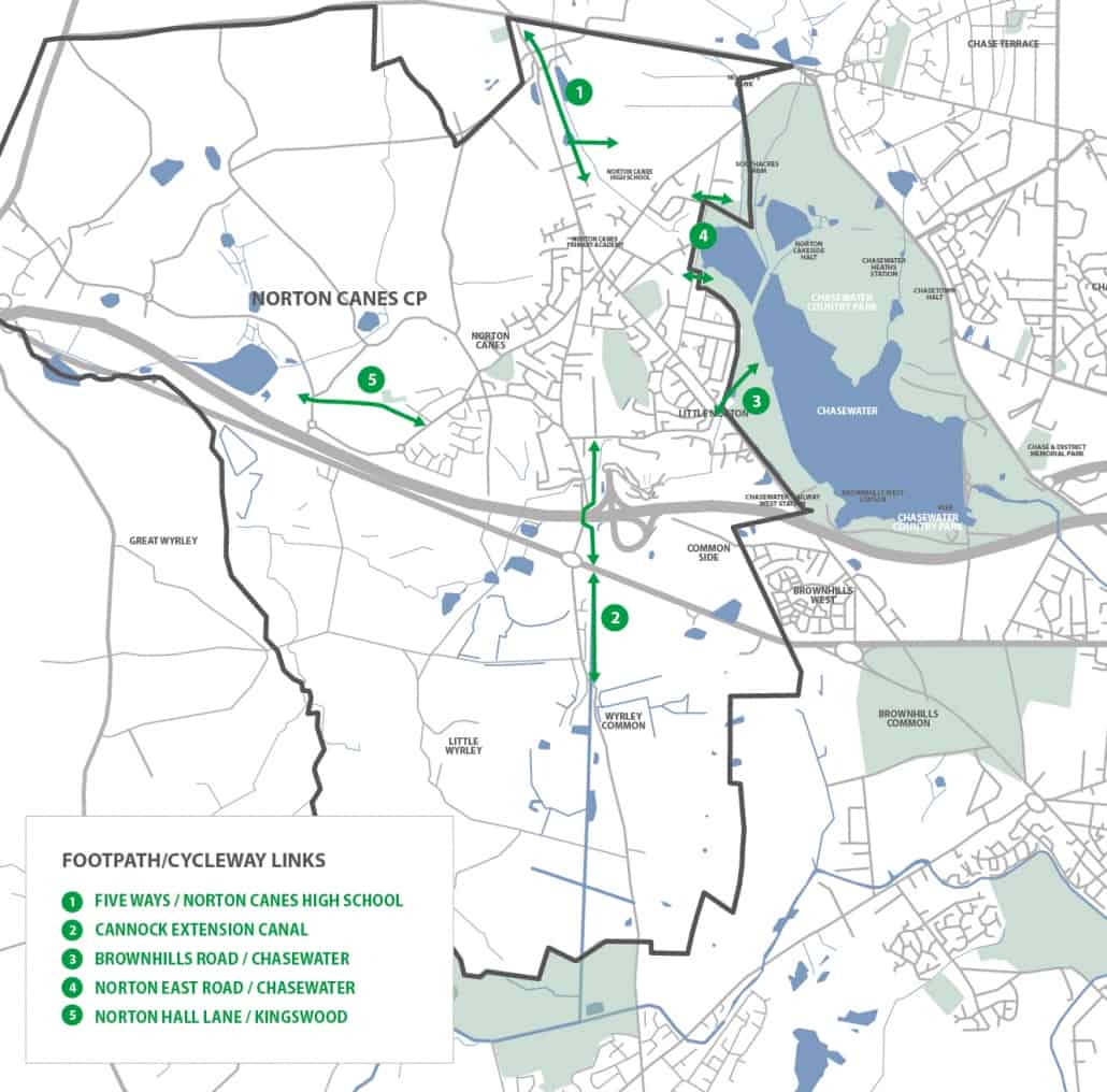
[Insert new image which includes link 6]
We want to prioritise delivery of improvements to the key walking/cycling routes described above and ensure major new developments include appropriate contributions to deliver sustainable travel gains.
Our Policies and Proposals
Draft Policy ST1 – Work with landowners the District Council and the County Council to deliver the footpath/cycleway improvements, resolve the issue of obstruction and seek the potential realignment described in items 1 to 6 above. Seek to agree with the District Council a requirement that funding be allocated via S106 agreements and CIL provided by developers/landowners in connection with major new developments.
Draft Policy ST2 – Explore with Highways England , Staffordshire County Council and the developers of the proposed extension to Watling Street business park, to provide a safe crossing of the A5 for pedestrians and cyclists between the Rising Sun and Turf Islands, ideally close to the Cannock Extension Canal towpath.
Draft Policy ST3 – Work with Staffordshire County Council and bus service operators to secure sustainable improvements to bus services including a commitment to retaining the existing developer funded service improvements and seek to deliver evening services with future developer funding.
