What do you think of local travel? is it adequate or where could it be improved?
![]()
We want to improve bus services and walking and cycling routes to give better access to jobs, shopping and other facilities.
Up to £575,000 to spend on bus services will become available to Staffordshire County Council via a legal agreement in connection with the housing development off Norton Hall Lane.
Connecting the south western end of the village with the village centre, Kingswood Lakes Business Park and Cannock Town Centre have been proposed as a priority for use of this funding.
We may want to ask for some of this funding to pay for some form of ring and ride community transport.
To obtain information on how local people use the bus service we have carried out a survey.
Answers showed that:
- Most users are over 65 and female
- The majority of trips are to Cannock, Lichfield & Walsall
- Most trips are for shopping or health appointments
- Most users had bus passes
- Few people use buses for journeys to work
The main issues appear to be:
- Services are not frequent enough
- Services are not reliable enough
- Services should be extended to run from 6am to 11pm and on Sundays
- Fares were too expensive
We want to address all these issues by working in partnership with the County Council and D&G Bus to deliver sustainable improvements to services.
Walking / cycling
As well as improving public transport, we want to make sure people can get around the area easily on foot or on bike.
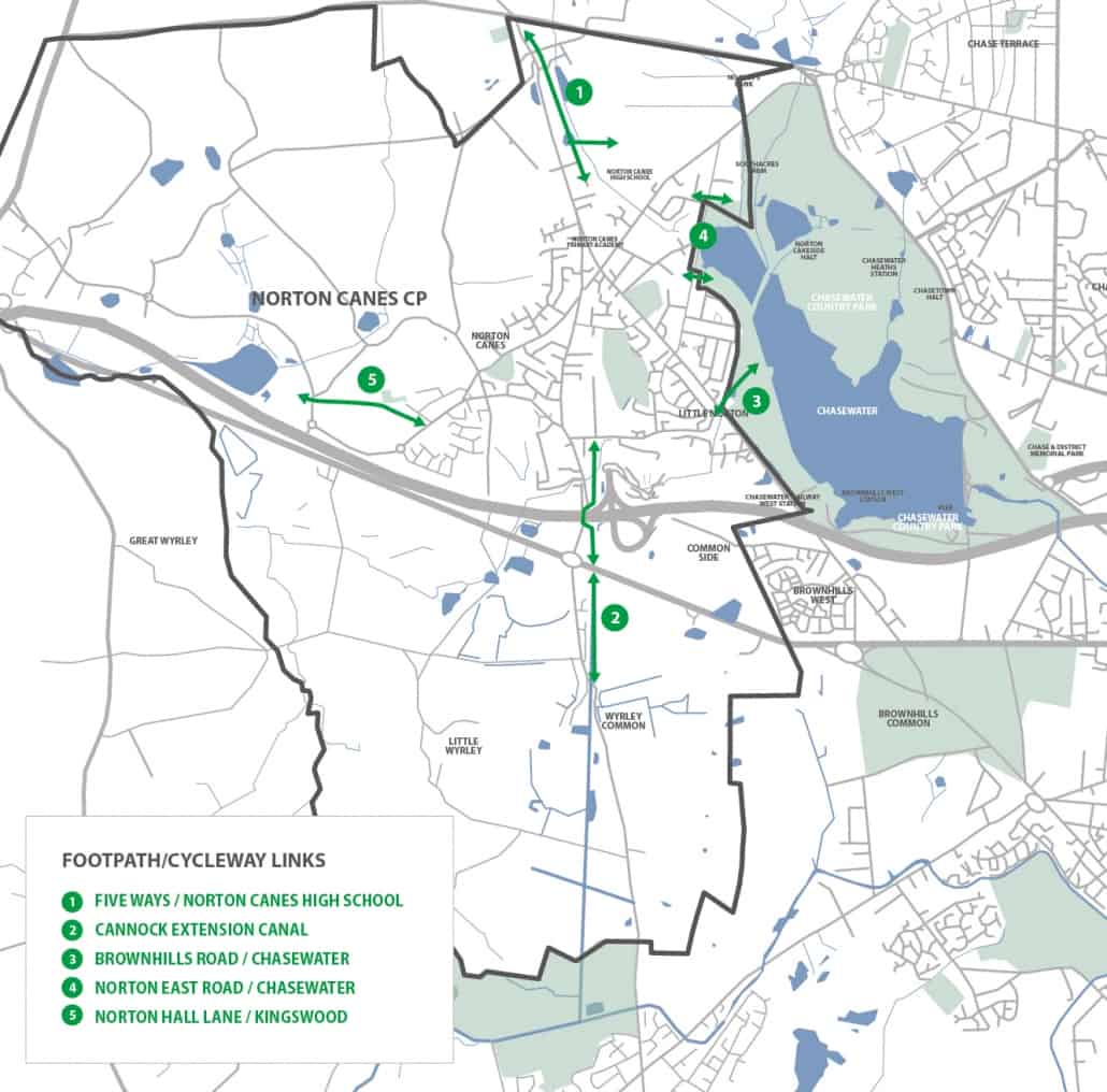
There are five key walking/cycling routes to and from the village which we think should be improved:
- 1 – FIVE WAYS/NORTON CANES HIGH SCHOOL
Footpath/cycleway link via the former colliery railway track south of Five Ways to the high school – this would help high school pupils who live at the northern end of the catchment area - 2 – CANNOCK EXTENSION CANAL
Linking the village with the A5 via the former Cannock Extension Canal route which is currently partly blocked and has an unsafe crossing of the A5. This would help workers on Watling Street and Lime Lane business parks, users of retail/food and drink facilities on the A5, and leisure users accessing the canal towpath south of the A5 - 3 – BROWNHILLS ROAD / CHASEWATER
Footpath link from Brownhills Road opposite Red Lion Lane to Chasewater. This path gets badly waterlogged. - 4 – NORTON EAST ROAD/CHASEWATER
The two footpath links from Norton East Road on either side of the western edge of Chasewater. This would help people access Chasewater more easily. The path to the south is currently not accessible for those with mobility issues and does become waterlogged. - 5 – NORTON HALL LANE/KINGSWOOD
For workers and leisure users looking to access the employment, shopping and open spaces of Kingswood and the Orbital Centre, there is no safe access from the south-west of the village.
We want to prioritise delivery of improvements to the key walking/cycling routes described above and ensure major new developments include appropriate contributions to deliver sustainable travel gains.


