
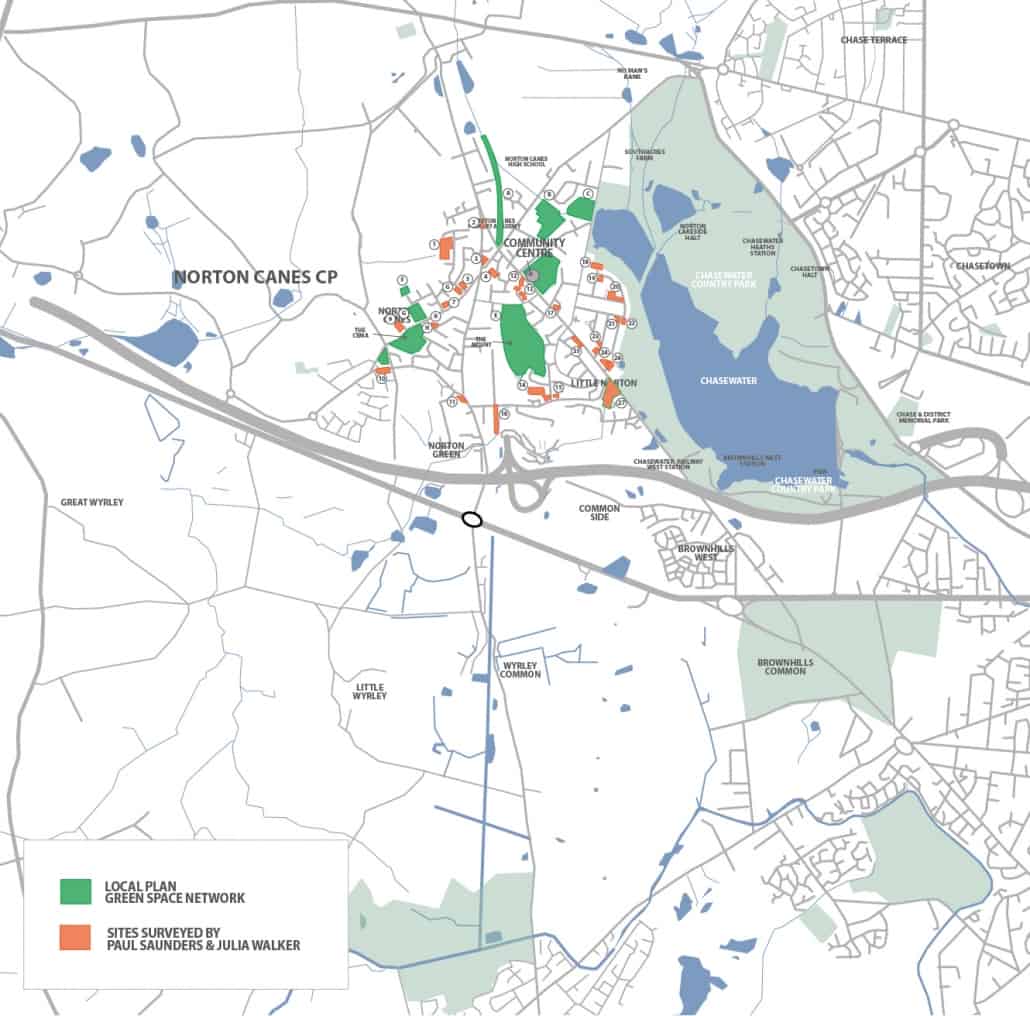
The map associated with this note shows two categories of open space within the village –
- Sites coloured green which are within the protected Green Space Network on the Cannock Chase Local Plan Policies Map 2014. There are 9 in total denoted A to I.
- Sites coloured orange which currently have no form of planning policy protection. These were surveyed by Paul Sanders and Julia Walker and then Paul Sanders and John Heminsley visited them together in order to make notes on current condition and identify possible improvements. These are numbered 1 to 27. Site 27 is currently in the Green Belt so is protected by this policy but the GB boundary is likely to be redrawn on this part of Brownhills Road as part of the Local Plan Review, because there is now a completed housing estate to the south which this open space has been provided to serve and it is separated from open countryside by the new houses.
Green Space Network
A – Former colliery railway footpath/cycleway including more formal area with coal tub on plinth at junction of Burntwood Road and Brownhills Road.
B – Playing fields of Norton Canes Primary School Burntwood Road/School Road.
C – Wooded area with limited access Norton East Road.
D – Recreation ground including football pitch and toddlers play area Brownhills Road.
E – The Mount open space between Jerome Road and Red Lion Crescent comprising informal space with paths and wooded areas plus formal play area and kickabout area.
F – Small area of mown grass off Kingswood Drive.
G – Playing fields of Jerome Primary School Chapel Street.
H – “The Cema” informal open space plus play area Chapel Street.
I – Part woodland and grassed area Norton Green Lane/Church Street/Butts Lane
Sites surveyed by PS, JW and JH
1 – Chasewater Way large area of mown grass popular with dog walkers, potential for some tree planting.
2 – Hednesford Road/Brownhills Road triangular grassed area with small trees in need of improvement.
3 – Hednesford Road/Burntwood Road memorial garden well maintained.
4 – Rear of village centre car park grassed area with trees well maintained.
5 and 6 – Grass verges on each side of Chasewater Way/Chapel Street junction potential for tree planting.
7 – Grass verge Hussey Road/Chapel Street junction potential for tree planting.
8 – Grass verge Bridges Crescent/Bridges Road potential for tree planting.
9– Large area of grass adjacent to Castlecroft potential for tree planting.
10 – Norton Green Lane/Butts Lane grassed area currently used by local Guides and Brownies.
11 -Grass verge junction of Walsall Road/Norton Green Lane potential for tree planting.
12 – Attractive landscaped path linking Brownhills Road and The Brambles.
13 – Landscaped areas alongside the Brambles.
14 – Red Lion Crescent play area in need of improvement.
15 – Grassed area corner of Red Lion Lane/Red Lion Avenue in need of improvement.
16 – Former canal footpath route south of Betty’s Lane in need of improvement.
17 – Triangular plot with tree corner of Park Avenue/Brownhills Road well maintained.
18 – Large grassed area and car turning space at northern end of Pool Avenue – potential for tree planting and access improvements to Chasewater.
19 – Large grassed corner plot Pool Avenue/St. James Road potential for tree planting.
20 – Wooded area on corner plot with extended grass verge in reasonable condition.
21/22 – Grass verges on corner of Silver Birch Road and High Street in need of improvement.
23 – Corner shrubbery Cherry Tree Road/Elm Road in need of improvement.
24 – Grass verge on Cherry Tree Road in need of improvement.
25 – Grassed area partly used for parking Brownhills Road in need of improvement.
26 – Triangular wooded area reasonably well maintained.
27 – The recently laid out open space between Red Lion Lane and Brownhills Road containing grassed and planted areas, paths and a Multi Use Games Area (MUGA) provided in connection with the Taylor Wimpey housing development and now adopted by Cannock Chase Council.
